The A1 is the UK's longest numbered road and possibly its most famous. But the part within London, from St Paul's to the M25, might be the most easily overlooked. Thankfully some of Youtube's favourite transport geeks are turning their attention to it - so to mark the occasion, here are five things you might not know about the A1 in London.
Several years ago, comedian and Youtube star (and, shhh, closet roadgeek) Jay Foreman made a very funny (and very factual) video about the London Ringways which was partly based on research on CBRD. Now he's joined forces with Geoff Marshall - yes, from All The Stations and all those videos about the Underground - for a look at the A1. I've played a very small role in the research for the video and thought it was worth sharing with CBRD's readership, but obviously we aim to completely outgeek them, so before we get to the video, let's revel in the things that a funny Youtube video for a general audience wouldn't touch with a barge pole.
1: The A1 is not the Great North Road
Not within the M25, anyway. Of the 16 miles of A1 in Greater London, only three miles are on the traditional route of the Great North Road. The other 13 miles are on bypasses built at one stage or another to improve the flow of traffic and make the journey easier in one way or another. From south to north:
- Goswell Road (from St Paul's to Angel) carries the A1 parallel to the ancient route along St John Street
- Archway Road was built in the nineteenth century as a bypass for the steep hills on the Great North Road through Highgate
- Aylmer Road - and then Falloden Way, Great North Way and the whole of the road from Archway to the M25 - is part of the 1920s Barnet Bypass
The Barnet Bypass, opened in about 1928, is an incredible piece of inter-war roadbuilding, replacing at a single stroke more than 17 miles of the original A1 route through Finchley, Barnet, Potters Bar and Hatfield. It runs from Archway in North London to what is now A1(M) junction 4 at Stanborough north of Hatfield - a bypass so long and so much a part of the furniture that most people today don't realise it's a bypass at all. More on that in a moment.
2: The A1 has the most accurate maths
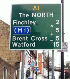
On the northbound A1 at Archway Road, there's a green route confirmation sign that lists the distances to Finchley, the M1, Brent Cross and Watford. A few years ago someone added a series of mathematical operators to the sign with white plastic insulation tape to turn the table of mileages into an equation, making a surprisingly well known London landmark and a social media meme.
3: The A1 doesn't reach the hub of UK road numbers
Not that there is, in any truly meaningful sense, a satisfyingly organised place where the single-digit A-roads radiating from London all meet. London's organic and often wilfully haphazard road network does not allow for that. But Bank junction in the City was historically the meeting point of the A3, A4, A10, A11 and A40. The A1, which you'd think would reach any central point like that, has always fallen disappointingly short and starts - as it always has - on the A40 a little way to the west at St Paul's.
Why exactly the A1 should give way to the A40 on the last few yards of its long journey into the centre of London is anybody's guess, but it is the A40 that, for some reason, takes precedence on the way in to Bank over not just the A1 but also the A5.
Today the A1 starts at the big roundabout called the "Rotunda" below the Museum of London, a little way to the north of St Paul's, because of a one-way system that causes St Martin's le Grand, the street that used to carry the A1 to the cathedral, to become part of the A40.
4: The A1 is the reason for three place names
Well, the Great North Road is - and in fact it'll be the cause of a whole host of place names along its route up to Edinburgh. But in the London area, there are three places that directly take their name from the fact the Great North Road passes through.
- Holloway in North London - still traversed by the modern A1 on the three miles it still shares with the traditional Great North Road - is thought to derive from "hollow way", a reference to the well-worn roadway used for droving cattle into the city.
- Archway got its name from the original arched bridge built in 1896 to cross the man-made cutting that carries Archway Road - the A1 - up the hill past Highgate. The road was named for the fact it passed under such a grand archway, and the area (and its Tube station) adopted the name as the suburb grew.
- Potters Bar, just outside the M25, gets the "bar" part of its name thanks to a toll gate that would have once blocked journeys on the Great North Road in the turnpike era.

5: For a long time the A1 was not the A1
Or at least the Barnet Bypass wasn't. If you travelled out of London in the first half of the twentieth century, a smashing bypass existed to get you past all the tedious bits of road through everywhere from Finchley to Hatfield - but it wasn't the A1.
When the new Barnet Bypass opened in 1928 there was a policy to assign new numbers to new roads, so the A1 stayed faithful to the old Great North Road, and the new bypass was split into three parts: the utterly unmemorable A5092, the downright obscure A5093 and (for the middle section shared with the Watford Bypass) the decidedly uninspiring A5088.

In 1935, someone at the Ministry of Transport realised that this situation was a bit silly and that the Barnet Bypass should be given a number that would indicate its status as a major road in and out of London, so they renumbered it to the A555. That was certainly better, but still not what we would now consider the obvious solution.
In 1954 sense finally prevailed and - as part of a London-wide rationalisation of road numbers and signposting - the A1 finally moved on to the Barnet Bypass, where it has stayed ever since.
The A1 in motion
If the road facts have given you an appetite to explore the A1 in London more closely, you can either drive it or - much more enjoyably - you can watch the video here or on Youtube.
![]()
Comments
When I was a boy we used to go by overnight coach from Victoria Coach Station to Glasgow. As I remember the coaches went up the A1 to Scotch Corner, then took the A66 to get across the Pennines and take the A74 to Glasgow. We stopped at a lot of towns en-route. Company was Western SMT as I recall
Strictly speaking, the original road numbering scheme of 1922 did not yet cover the City of London and so for the first few years of its existence the A1 started on the line of the city wall at Aldersgate, adjacent to Barbican station.
Add new comment
Picture credits
- Picture of Archway Bridge taken from an original by Robert Lamb and used under this Creative Commons licence.
- Map of the A5088, A5092 and A5093 is from the Times Map of London, undated but out of copyright, courtesy of SABRE Maps.
I have seen old A to Zs which have the A1 continuing across the A40 to follow St Paul's Churchyard (now pedestrianized) parallel to Old Change, to Cannon Street (the A4). http://maps.nls.uk/view/103018885
One 1950s map (not on the internet) even shows it continuing along Friday Street to end at the junction with Queen Victoria Street.