View east from Hill House Farm to Sandy Lane, 12 December 1997

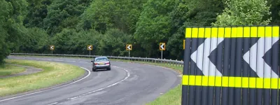
View east from Hill House Farm to Sandy Lane (see all photos of the same view)
At the bottom left of the picture, the boundary fence for the motorway has moved to the bottom of the embankment. This cutting slope has been designed to be much shallower than is strictly necessary and its shape blends in to the natural slope of the land, with the intention that most of it would be returned to farmland. This helps the motorway fit in to its surroundings more naturally. Visible here are Hill House Farm bridge (in the foreground) and Sandy Lane (in the distance).
Structure 16 (Sandy Lane overbridge)
Structure 16a (Hill House Farm overbridge)
B5256 Sandy Lane
What's new
Farewell GLC lights
Why am I all nostalgic about some street lights being replaced?
Silver bullet
The Silvertown Tunnel is finally open for business. One question remains: what’s it for?
Skid Risk, Accident, Fog
For the first time, we can share pictures of the pioneering experiment that lit up the Worcestershire countryside with enormous signs 61 years ago.
Have you seen...
Mickleham Bends
Once it was one of the UK's most dangerous roads — just what is so special about a bit of dual carriageway in Surrey?