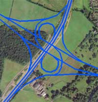
Glasgow's plans were documented in enough detail that they can be plotted onto modern mapping. Here you can see the whole plan on a detailed map of Glasgow.
Roads.org.uk has published a map overlay showing the whole plan, accurate to within a few metres, and showing all junction layouts. It is a mix of A Highway Plan for Glasgow and The Greater Glasgow Transportation Plan: in general, where the two differ, the map shows the most interesting variant, and usually favours the original proposal.
You can view it online courtesy of SABRE, or you can download it for use with Google Earth or similar software.
View online
The map is available to view on SABRE as a scrollable, zoomable interactive map.
View Glasgow map on the SABRE Wiki
Download the overlay file
Download the file below and double-click it to open it with Google Earth. (If it doesn't open automatically, you can instead open Google Earth and then drag the file in.) You will see a new item in the 'Places' box to the left of the screen, called Glasgow.kmz, and the program will zoom to an overview of the Glasgow area showing the proposals.
You can zoom and scroll around the map as normal; the roads will show at all altitudes. As you zoom in you'll be able to see the individual junction layouts.
About Google Earth
If you don't already have Google Earth, you can download it for free from google.com/earth. It works with Windows, Mac and Linux, and requires a high speed internet connection. Roads.org.uk is not affiliated with Google and is not responsible for this software.
Glasgow Google Maps overlay
122.75 KB