One of the nice side-effects of an enormous road plan that was never properly cancelled is that signs of it show up everywhere. All across Glasgow, the geography of the city drops hints at what was once planned.
In some places like Townhead Interchange (right), bits of unfinished road exist, never driven on and pointing to buildings that will never be cleared now. Elsewhere, the game is given away by bits of empty land; protected corridors through the suburbs that to the untrained eye just look like a patch of grass here and a cluster of trees there. Without knowing the intimate details of the plan many are impossible to see - but, of course, the intimate details are what we now have. This page explores just a handful of the many examples of the plan's legacy.
M8 sliproad slip-up
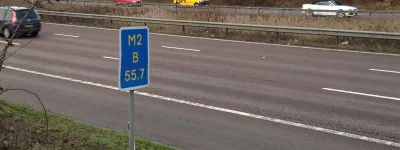
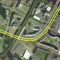
The present-day southern terminus of the M80 was actually meant to be a four-way interchange, with a motorway roughly on the M80 line crossing the M8 and continuing to the south to become the South Link Motorway. The junction that was planned was limited access, with sliproads connecting the north to the west, and the east to the south.
When the M80 was finally built, opening in 1992, the junction built was a simple fork, with some sliproads to the local unclassified street network. But the junction still hints at what was once planned, in the east-facing sliproads connecting the M8 to the local road. These sliproads were built with the M8 in the early 1970s and, presumably, were plugged in to the local road as a temporary measure until the junction was completed.
Of course, it never was - but a look at the layout shows that they are aligned perfectly to form sweeping curves towards a non-existant motorway to the south. Below is a diagram of the junction today alongside the original proposal for the interchange.
The wide verges of Ruchazie
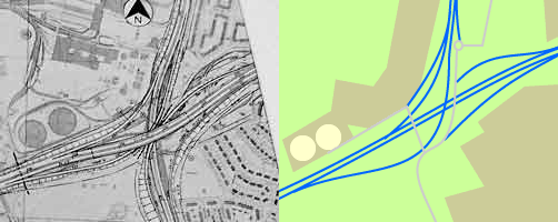
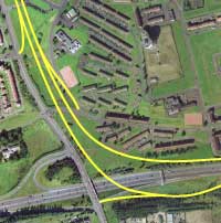
A short distance to the east is Ruchazie, an interchange giving local access to the M8 and a number of housing estates built in the 1960s with wide grassy areas typical of the era.
It looks completely innocuous from the air - but in fact one of those wide grassy spaces, between some blocks of flats and Stepps Road, connects with some unusually wide verges on the M8, leaving the perfect amount of space for the North Link Motorway's terminus.
The diagram to the right shows the intended use of all that open space and the reason for the shape of the housing estate to the north-east. It includes a junction further up Stepps Road, currently a well-designed T-junction close to the end of the dual carriageway, that was supposed to include an entry point to the motorway.
Dual carriageway giveaway
One clue that can sometimes be found where a road was once planned is to find another road in the same place. The route of the Liverpool Inner Motorway, for example, is largely followed by incredibly wide surface streets today. The reason is simple: the land for part of a road scheme is compulsory-purchased, but when the road doesn't get built it is recycled for a smaller-scale road improvement.
Glasgow contains a helpful marker if you're trying to find the lines of the south and east sides of its unfinished Inner Ring Road - a very short dual carriageway that runs only for the length of its southeastern corner. The buildings on either side of this road are relatively new, and historically all the streets in this area were in a grid pattern. It's a fairly safe bet, then, that this land was reserved for the corner of the Inner Ring, and has more recently been put to use for a surface dual carriageway - which, thanks to the shape of the available land, has taken on the motorway's curve.
Glasgow ski jump
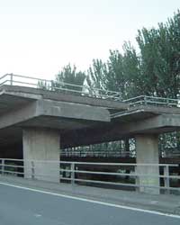
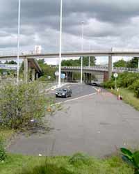
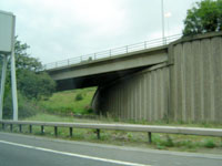
South of the Kingston Bridge, two of the M8's five lanes in each direction split from the main carriageway, curve around to face east, and then swerve off the viaduct and down to the nearest ground-level street. It's unfinished business on a grand scale, with a dual two-lane mainline stub hanging in mid-air waiting for its continuation as the south side of the Inner Ring Road.
What makes it particularly interesting, however, is that the completed sliproads hold some clues too. The northern one, allowing traffic off the motorway, has an unexpected curve in it, designed to allow the sliproad from the M8 eastbound to pass over the top easily.
Sadly this unfinished end will not be plugged in if the M74 is completed - the new motorway will pass to the south and merge with the M8 slightly further along, with no access to the Kingston Bridge.
The other end of the incomplete Inner Ring Road is even more obvious; a look at Townhead Interchange (M8 J15) shows a host of sliproads pointing to what was to be a four-carriageway motorway to the south. The sliproads connecting with the M8 to the west join and leave on the right-hand side of the motorway, for the simple reason that they were meant to form the through route.
The Maryhill rollercoaster
The junctions on the central Glasgow section of the M8 - the part that was intended to be half of the Inner Ring Road - are incredibly close together. The only place there is any relief from the relentless onslaught of sliproads is between junctions 16 and 17, an elevated four-lane section that is mercifully peaceful. It isn't at all like the designers of this road system to leave such a gap in their Inner Ring Road - and of course the reason there's a gap in the junctions is purely because another one was meant to be squeezed in there.

It was the southern terminus of the Maryhill Motorway, and the odd undulations of the two parallel motorway viaducts are down to the split-level junction design. Both carriageways would have had an exit to the Maryhill Motorway at a lower level before climbing uphill to merge with an entry sliproad. The other motorway isn't there, but the stubs for its sliproads certainly are, clearly visible from the road. Travelling westbound the exit sliproad is particularly prominent as more than a stub - it's a short section of surfaced carriageway that passes under the eastbound carriageway before stopping abruptly.
Carefully spaced Cumbernauld
Around the fringes of Glasgow's urban area are several New Towns - Cumbernauld and East Kilbride are the two main ones, but areas like Erskine were also developed in the 1960s and 1970s as planned communities. They all have vast swathes of empty space waiting for future road schemes.
The northern terminus of the A73 in Cumbernauld was, until recently, a small roundabout that caused incredible traffic problems. It was isolated in the middle of vacant land, but otherwise surrounded by built-up areas.
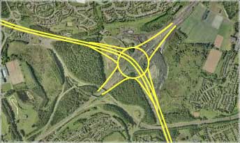
The reason is quite simple: an expressway in from the north was to cross the A80 here, turning into a motorway (what is now A73) as it passed through. The flat roundabout was just a temporary measure. The diagram above shows a three-level stacked roundabout, which appeared here in the 1967 plan, though diagrams have been found showing what appears to be a much larger free-flowing interchange. This may explain the large surplus of land around the junction.
Other examples
Of course, the examples of unfinished business detailed above are just a handful of the clues the two highways plans left strewn across Glasgow. If you take a look at the plan using the overlay map, zoom in and look carefully along the line of many of the roads and you'll find the evidence quite easily.
The route of the North Link Motorway is a good start, with areas of empty land almost all the way along its line - the only substantial blockades are housing built in the last two decades. Likewise, the housing developments south-west of Paisley, around the banks of the reservoir, were obviously designed with the motorway in mind.
Everywhere, across the city, you'll see built-up areas that end in a curve that conveniently matches that of a non-existant sliproad, trees cleared for no apparent purpose along a motorway alignment, and so on. Half the fun of Glasgow's unfinished roads is just in knowing where to look.
Picture credits
- Images of incomplete carriageway stub, 'ski-jump' and incomplete Maryhill interchange are taken from originals by Steven Jukes; used with permission.
- Aerial photography is courtesy of Google Earth.