Croydon Ring Road:
Route map

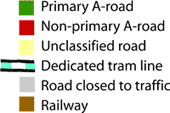
To help orient the lost traveller who is not yet familiar with this part of South London, here is the full glory of the Croydon Ring Road, such as it is, in stylised map format.

This diagram includes the various odd concessions to the Croydon Tramlink system and the very numerous places that traffic stops at traffic signals, despite the various flyovers and underpasses on the way.

In this section

What's new

Silver bullet

The Silvertown Tunnel is finally open for business. One question remains: what’s it for?

Skid Risk, Accident, Fog

For the first time, we can share pictures of the pioneering experiment that lit up the Worcestershire countryside with enormous signs 61 years ago.

All change

In July 2024, a new Government entered office with a very different set of priorities. What does it mean for a faltering roads programme?

Share this page

Have you seen...

Above the M8

Go to Glasgow and it's almost inevitable that you'll use the M8. The views of the city surrounding it are really quite unique.

About this page

Published

Last updated