History
While Rannoch Moor may be one of the last true wildernesses in the British Isles, it has for centuries provided the main link between the West Highlands and the Central Belt of Scotland. In medieval times, almost from the birth of any kind of market economy in Scotland, cattle were being herded across the moor to be sold at market. These drovers' routes were probably marked by cairns on small knolls, signifying the safest routes.
One such route was the Road to the Isles. This may be the modern tourist name for the A830, but its origins go back much further, with the historic drove route running from Arisaig, through the dangerous Glen Nevis, and then crossing the eastern fringe of Rannoch Moor, past Corrour, and into the upper reaches of the Tay Valley.
Another route skirted the western fringe of the moor, to reach Strath Fillan and so the shores of Loch Lomond, much as the modern A82 does today. It was this route that General Caulfeild decided upon when planning the Military Road North. Work was only carried out in the summer months, from late April or May until September. The road across Rannoch Moor from Tyndrum to Fort William was, by all accounts, completed in two summers - 1751 and 1752. Such a rapid progression suggests a large number of work parties each building their own sections. It would also go to explain the poor quality of road that Telford found fifty years later.
As with most modern travellers, Caulfeild started from the south, using existing tracks and drove routes to reach the inhospitable edge of the moor at Bridge of Orchy. The current crossroads outside the Hotel shows Caulfeild's route, and the bridge over the River Orchy is the bridge that he constructed in 1751.

The route was then constructed at a relatively high level on the hillside to minimise construction costs. The higher up, the smaller the streams, so fords would make do in place of bridges. Wherever possible the materials were gathered from the surrounding landscape - stones and pebbles - with the small quarries still visible along the route. Sand and gravel would almost certainly have had to be imported, probably in small carts along the road to the current construction area.
The road was built by soldiers, and there are a number of tales surrounding the construction of the Military Roads. One of the most popular is that for every soldier digging, there were three on the surrounding hillside ready with their rifles to fend off the "marauding Highlanders". This is probably largely a myth for Rannoch Moor, as it is doubtful that there were ever many people resident on the moor. However, as the road neared Glen Coe the memories of the Massacre of fifty years earlier would have still been fresh in their minds. It is possible that this had a serious bearing on the chosen route, as it crossed the steep hills to Kinlochleven to avoid entering Glen Coe itself.
The name "Devil's Staircase" was given to the zig-zag climb up the hillside. The route is just as steep as it looks and makes for a difficult ascent.
The soldiers would have been camped in makeshift tented villages, and while winter conditions would have been pretty harsh, it was still seen as a choice role by many in the Army. The forts, barracks and other garrisons in the highlands were pretty dangerous places to be in the 18th Century, with numerous attacks and sieges recorded. As the roads neared them, the rapid movement of troops gave the army a gradual superiority with their better weapons, and the ultimate absorption into British Society of the Highlanders. However, it was a long and complex tale, with clearances, potato famine and mass emigration playing a big part.
The route
From Bridge of Orchy, General Caulfeild's road climbs steeply, using what is now the West Highland Way (WHW) to Inveroran and then joins the public road to cross the River Abhainn Shira at the Victoria Bridge. From here, the General opted for a high level route, to try and avoid the treacherous bogs of the lower moor, and also reduce the expense of building too many large bridges: many of the streams were crossed with cobbled fords.
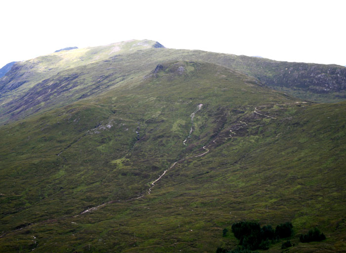
When the road reaches Forest Lodge, the course of the Old Military Road has been obliterated, and despite its onward route being clearly marked on the OS map, it is hard to trace in the landscape. However, it is there. A rough sheep track through the Heather marks the right-hand (eastern) edge of the road as you head northwards, and where the road climbs over small knolls, the full width becomes apparent in the dry, stony surface. The width seems to have been approximately 5m (15 ft).
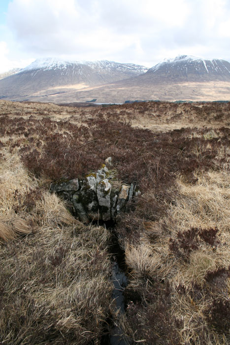
Once you have finally located the old road in the endless peat bogs and heather, a few tell-tale signs such as this fine arched culvert (shown left; click to enlarge) confirm your location. Although partially collapsed, it proves that the road once ran this way. Indeed, the harder you look, the more you find. In places, rows of larger boulders appear to form kerbs along the side of the road, while many of the small lumps and bumps along the route have been dug out as on-the-spot quarries to provide stone for the surface and structures.
About 4Km (2½ miles) north of Forest Lodge, the now-invisible Military Road rejoins Telford's route for nearly 3Km (2 miles). Half way along this stretch is the Ba Bridge, and while the current Structure may be Telford's, General Caulfeild would also have needed a significant structure to cross this fast flowing river.
The OS map marks the next stretch of the Military Road as a mere path, rather than the track marked previously. However, it is much clearer and more well defined as it climbs from the WHW. The features along the route are much as before, but this time the views are spectacular, with the full sweep of the moor laid out to the east.
As the route starts to drop back down towards Telford's road, the views into Glencoe seem quite desolate, so the sight of the Kingshouse Hotel (reputedly the oldest Inn in Scotland) is very welcome! Shortly after rejoining the WHW, the route becomes public road at Blackrock Cottage, before crossing the modern A82.

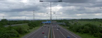
Beyond Kingshouse, Telford's road soon diverges to take the route now used by the modern road, while the WHW runs along the hillside higher up. The maps mark this as the route of the Military road, but on the ground there is little evidence to support this. After 250 years nature has reclaimed the road and the modern footpath uses timber bridges to cross the streams, while weaving round boulders that almost create a new alignment.
After about 5.5Km (3½ miles), the Old Military Road once more reappears in it's own right. The steep climb from Altnafeadh leads to the even steeper zigzags of the Devils Staircase. It is this route that the WHW also takes to get to Kinlochleven, and through the Lairig Mor to Fort William. All subsequent main routes have taken the far easier gradients through Glencoe, which is part of the original drovers route.
Apart from the concerns over problems with the residents of Glencoe, this route also avoided the need for any kind of ferry across Loch Leven, and the Lairig Mor is in many ways a much more suitable route for a modern road than the precarious ledge along the shore of Loch Linnhe that the A82 uses. It should also be remembered that the military roads were built primarily for troop movements: animals, carts and other wheeled traffic were very much of secondary importance when the roads were surveyed and built.