History
At the Beginning of the 19th Century, with a booming economy, the United Kingdom was seeing major investment in its transport infrastructure. Generally speaking this was through the dubious good works of the Turnpike Trusts. However, in the remote Highlands such organisations had little or no hope of ever turning the all-important profit.
As a result, the government intervened and commissioned Thomas Telford to survey and consult on improvements and new routes, including for the Caledonian Canal. There were many reasons behind this decision, not least the need to stem emigration and provide work for the local men. Supporters included many of the Highland Landlords, the Fisheries Commission and the Military. It was 1803 when Telford himself crossed Rannoch Moor to survey General Caulfeild's Road, and found that it was already falling into disrepair. His main principles as an engineer, throughout the Highlands, were to take the gentlest gradients, with substantial bridges and box culverts in place of cobbled fords. This was to ease the passage of Carriages and other wheeled traffic. The surface was also to be dressed with 'a good depth' - records suggest 30-40cm (12-15 inches) - of gravel to prevent damage to the hooves of the livestock on their way south to market.
The construction was funded by a novel set of methods, with fifty percent coming from the Government. The remainder was to be provided by the landlords and communities that the roads would serve, although the complexities of Scottish law and tenure almost made such a proposition impossible. An Edinburgh Lawyer named Hope, who spent twenty five years working alongside Telford's team, eventually created ways round these problems. Much of the money came from an early council tax levied by the County Councils for the sole purpose of raising money for the roads. Land was deemed to be donated by landlords, in return for the benefit of better communications that the road would provide.
In the early stages of construction, Telford's workforce were housed in makeshift tented villages, much as the soldiers had been fifty years earlier. However, as work progressed and particularly after the end of the Napoleonic Wars, Caravans were provided, sleeping up to 16 men in bunks. These facilities were still in use at the end of the century for the maintenance gangs who repaired the route, although with the advent of first steam and then motorised vehicles the tradition of the workmen sleeping on-site slowly died out.
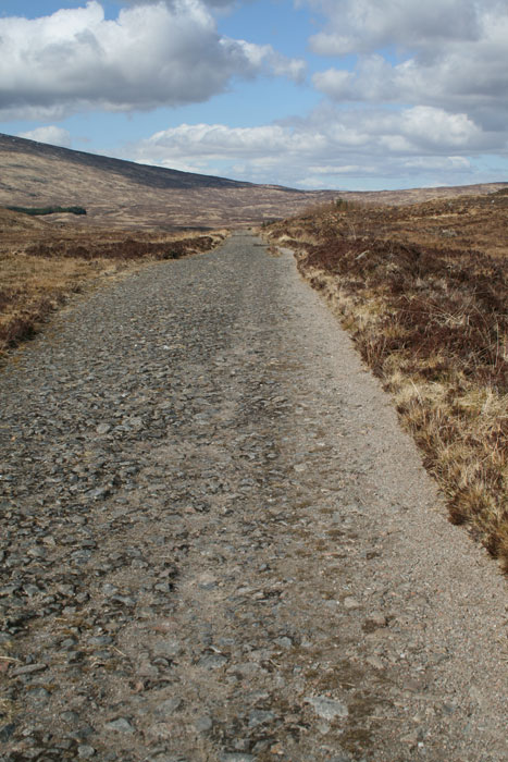
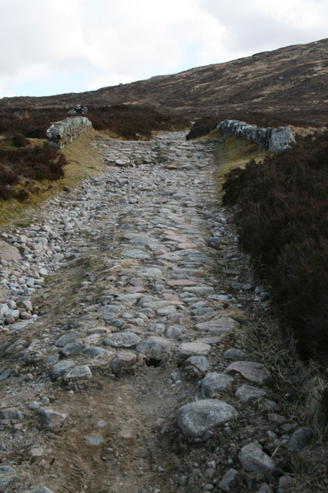
Despite being replaced in 1933, Telford's road still exhibits many of its original features as it continues in use for both Estate vehicles and as the long-distance path, the West Highland Way (WHW). The bridges are varied in both size and style, while the carriageway is still well drained and approximately 5-6 metres (15-18 ft) across.
The maintenance and construction of former Military Roads came under a different process to new road construction, and so work was able to get under way fairly quickly. I have not, as yet, been able to find out when the Rannoch Moor road was rebuilt, but suggest that it was one of the first, simply to enable traffic to travel further north.
However, in 1811 Telford was arranging the surveying for a supplementary drovers' route across the moor, running from Glen Spean along the shores of Loch Treig, via Loch Ossian (as the Railway ran 80 years later) and so to Killin. Due to the wide spectrum of interested parties (Land owners, Drovers and farmers from Lewis and Caithness to Perth and Falkirk), the organisation required to meet all of their requirements and raise the capital became impossible and the plan was abandoned. When considering the problems that the railway found, it is perhaps just as well that such a road was never built, as the construction and upkeep would have required a bottomless pit of money in those early years.
The route
The first 200 metres of Telford's Road out of Bridge of Orchy, across the eponymous Bridge, re-used the alignment of the Military Road. However, once across the river, Telford turned due north along the western bank of the river. He gently navigated the contours around Mam Carraigh and along the shores of Loch Tulla, so avoiding the 'unecessary' ascent to 320m, climbing to just 180m at Inveroran Hotel where the two routes converged once more. Despite adding roughly a mile to the journey, it is likely that only a few minutes were lost on this easier route.
This section of road was, until the 1980s, an A-road bearing the number A8005. With the Ministry of Transport assigning the numbers in the early 1920s, it seems probable that the whole of the route described below was the A82 until 1933, so was it renumbered as the A8005 then? The reason for doing so is obscure, as there was no intention to maintain two roads across the moor and the A8005 was always a dead-end.
A gate was placed across Telford's road just beyond Victoria Bridge, which - until the 1980s - bore a sign reading "ROAD CLOSED / ARGYLL COUNTY COUNCIL / LOCHGILPHEAD FEBY 1933". However, at least two publications from the late 1930s indicate Telford's route as still being public highway, so it was evidently closed only to road traffic.
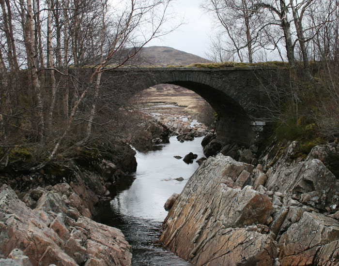
After crossing the Victoria Bridge (its name suggesting that it post-dates Telford), the two routes diverge again at Forest Lodge, where Telford's road took a route lower on the hillside. Below is one of the fine bridges that he designed and built, although I suspect that the parapet is newer.

The road even today averages about 5 metres (15ft) in width, and the bridges are if anything a little wider between parapets. However, in a number of places, there appears to be a slightly wider section. This may only date from the early days of motoring, when passing places were found to be necessary.
The gradient is generally easy going, climbing from 200 to 300m in about 2km (1.25 miles), or averaging 1 in 20. As the road approaches an area known as The Moss in the boggy Ba Valley, Telford rejoined the Military Road. This may have been a simple necessity, as trying to construct a new route through the surrounding peatbog would have been difficult.
The surface is still in good condition, with a mixture of larger stones and smaller material making a consistent surface. However, having been superseded in 1933, it is unlikely that the road was ever tarred as we would recognise today (there is no sign of any tar/tarmac along the route). As a result, it must have been quite a bone shaking ride in those last years before the new road was finished, bouncing along on this rough surface with jagged rocks poking out at all angles. Even today, there is plenty of evidence that the road itself is avoided - for much of the length dusty tracks along the verges show where hikers prefer to walk! Nevertheless, the road is still well-drained and surviving on the surface of the peatbog.
As with the Military Road that had gone before, Telford's Road is lined by a series of small Quarries (shown below), where the knolls and bumps of the moor have been opened up to gain stone for the road and bridges. Generally, the stone seems to have been used as it came, only being dressed in any manner for the masonry of the culverts and bridges. However, the road surface would originally have been covered with finer material than survives now. Today, these grassy hollows provide a sheltered spot for a picnic, or a hideaway for the animals of the moor.

The Ba Bridge marks the halfway point between Bridge of Orchy and the Kingshouse Hotel. It is also the most impressive structure along the old road (shown left; click to enlarge). The bridge spans the River Ba, a fast flowing mountain stream which tumbles over craggy rocks as it makes it's way out into the morass of the Moor. About half a mile to the north lies the remote ruin of Ba Cottage, once as welcome a sight to the weary traveller as the Kingshouse, although nowhere near as grand!
A few hundred metres past the turning for Ba Cottage, the Old Military Road again climbs off to the west, to cross the 500m contour, while Telford's route curves further to the east, only reaching a summit of 445m. It then descends to join the public road at Blackrock Cottage. It was only with the opening of the Glencoe Ski resort that this section of road was brought back into use, while conversely the section on the other side of the A82, leading to the Kingshouse Hotel, was only taken out of use at a similar time when its new access was built!
Beyond Kingshouse, Telford chose an easier route than the Old Military Road to Altnafeadh - the route now used by the A82, but instead of climbing the difficult Devil's Staircase on the direct route to Fort William, he chose to improve the road through the Glen which had been built in 1786, thus formalising the traditional Drove Road through Glencoe.
Most of the way through the glen this road deviates from the modern Road, initially tending a little higher up the hillside, and then after passing The Study and the spectacular Waterfalls, it can be seen to the south, below the modern road. Again, many of Telford's bridges survive, and the road is still able to carry vehicles (at least where they can access it!).
Finally, where the modern road crosses the River Coe, Telford followed the 1786 road, staying on the North bank and following the minor road past the Clachaig Inn, and into Glencoe Village - again an obvious use of a traditional Drove Road through the village.
With thanks to Robert Simons for information regarding the A8005.