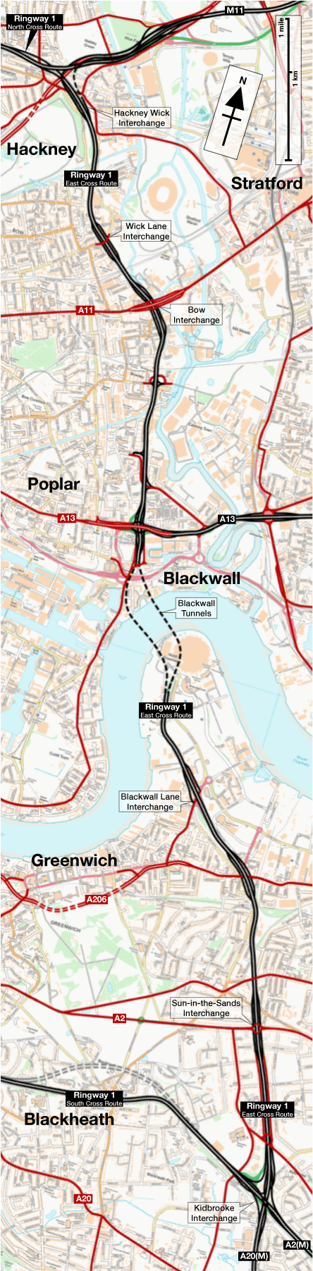
The East Cross Route is the black sheep of the Ringway 1 family. It's unusual because it is an existing road proposal that was absorbed into the Greater London Council's comprehensive Ringway plan, and is therefore the only part of Ringway 1 that would not have been an entirely new road.
It had been designed and partly built by the time the other three sides of Ringway 1 were unveiled, being a plan for a new road in East London to improve access to the Blackwall Tunnel that had been formulated by the former London County Council. This is why Ringway 1 would have used the Victorian-era Blackwall Tunnel to cross the river, and it's why you can drive the whole of this part of Ringway 1 today.
There had, for a short time, been a proposal for a separate motorway to form the east side of Ringway 1, but a good standard road ran parallel, so the expense of building another motorway alongside it would have been overkill.
The East Cross Route is lower in standard than the other parts of Ringway 1 would have been, with a sharply twisting alignment that makes extensive use of existing roads and works around obstacles rather than demolishing them. In parts it has footpaths alongside the main carriageways and buildings fronting directly onto it — including the entrance to Bromley-by-Bow Underground station.
For this reason, only two short sections, at the far north and south ends of the route, would have been a motorway. The East Cross Route would also have been narrower than the other parts of Ringway 1: plans for the North, West and South Cross Routes usually refer to four-lane motorways with full hard shoulders, and certainly the rest of Ringway 1 would have been that wide, but the East Cross Route just carries two or three lanes, and only has a hard shoulder where there's a bit of extra space.
Outline itinerary
![]() Continues from North Cross Route
Continues from North Cross Route![]() M11 and Eastern Avenue Extension (Hackney Wick Interchange)
M11 and Eastern Avenue Extension (Hackney Wick Interchange)![]() B142 Wick Lane (Old Ford Interchange)
B142 Wick Lane (Old Ford Interchange)![]() A11 Bow High Street (Bow Flyover)
A11 Bow High Street (Bow Flyover)![]() B125 Abbott Road
B125 Abbott Road![]() A13
A13![]() Blackwall Tunnels
Blackwall Tunnels![]() A2203 Blackwall Lane
A2203 Blackwall Lane![]() A206 Woolwich Road
A206 Woolwich Road![]() A2 Shooters Hill Road (Sun in the Sands Interchange)
A2 Shooters Hill Road (Sun in the Sands Interchange)![]() Rochester Way
Rochester Way![]() A2(M) and A20(M) (Kidbrooke Interchange)
A2(M) and A20(M) (Kidbrooke Interchange)![]() Continues to South Cross Route
Continues to South Cross Route
Cost summary
| Property acquisition and rehousing (1967) | £8,500,000 |
| Construction (1967) | £9,200,000 |
| Total cost at 1967 prices | £17,700,000 |
| Estimated equivalent at 2014 prices Based on RPI and property price inflation | £564,921,000 |
See the full costs of all Ringways schemes on the Cost Estimates page.
Route map
Scroll this map to see the whole route
Scroll this map vertically to see the whole route
Key to map symbols
| "Primary Road" Network | |
|---|---|
| Primary Road | |
| Primary Road section in tunnel | |
| Primary Road approximate or assumed line | |
| Primary Road cancelled or deleted before start of GLDP Inquiry | |
| "Secondary Road" Network | |
| Secondary Road single carriageway or of unknown formation | |
| Secondary Road known to be dual carriageway | |
| Secondary Road section in tunnel | |
| Junctions | |
| Location of Primary Road junction where layout is not known | |
| Location of Secondary Road junction where layout is not known | |
| Location of a junction cancelled or deleted before start of GLDP Inquiry where layout is not known | |
Route description
This description begins at the northern end of the route and travels south.
Hackney Wick to Blackwall
The line of the East Cross Route is simple to trace as, impressively, the whole thing was built. Its northern terminus was to be at a large free-flowing interchange where it was to take over from the North Cross Route. This junction, Hackney Wick, was never completed, but a journey along the East Cross Route today makes it obvious to even the untrained observer that something strange is going on here.
Only two of the four major roads approaching the junction were ever built, and most of it is missing, so the through route follows what were supposed to be sliproads, which take an inexplicably odd course through the junction, weaving through railway bridges and underpasses.
The southbound side follows a sliproad designed for westbound-to-southbound turns which runs through the Eastway Tunnel, a long cut-and-cover section that was designed to minimise the impact the road made on the nearby Calvary Church. The northbound side, meanwhile, passes under a lengthy railway bridge that almost forms a short section of tunnel itself. Aerial photos reveal that, apart from two tracks of the North London Line railway, the bridge is empty. It was designed for the many tracks of a goods yard that existed on this site when the road was designed, but as construction began in 1970, British Rail's goods services were collapsing at such rapid speed that the yard had closed before the motorway opened. Most of the railway bridge has never carried trains and probably never even had tracks laid on it.

To the west of Hackney Wick, the Eastern Avenue Extension was to skim Victoria Park on its way to Angel, deliberately mirroring the Westway at the other side of London. To the east is now the A12 but when the junction was designed it was intended for the M11 and Eastern Avenue travelling out towards Leyton. To the north would, of course, have been the North Cross Route. There are local sliproads at this junction, connecting to the A106 Wick Road, but these were intended to be temporary and would have been closed when the other motorways were built.
The East Cross heads south from here, and until 2000 this first section was a motorway, the A102(M). It is now the A12. The local junction at Old Ford was where the motorway ended. From this point the road is, officially, the Blackwall Tunnel Northern Approach. An impressive three-level interchange, the Bow Flyover, provides connections to the A11 at Bow Church. This is the oldest part of the route, with the A11 flyover coming first and the underpass for the East Cross Route added later. Today its tiny roundabout is widely known as one of the most dangerous junctions in London for cyclists.
There are then a succession of local access points before reaching the A13, a major road along the north bank of the Thames which the GLC intended to upgrade to form a motorway-standard route eastwards. The interchange that exists here, with tightly looped sliproads connecting the two roads together, was intended as a temporary measure and was to be replaced as the Blackwall Tunnels were improved.

At Blackwall, a new tunnel bore was added for southbound traffic when the East Cross Route was under construction. The original tunnel, which to this day carries northbound traffic, was built in the nineteenth century and has a very poor alignment and a low roof. It was intended that a third bore would be opened at a later date to allow the new major road to pass through modern tunnels, but this never happened. It does still get talked about: a dashed line marking the route of the third bore appears in A-Z street maps as late as the 1980s. There are now proposals for the Silvertown Tunnel, a twin-bore tunnel slightly to the east.
Blackwall to Kidbrooke
Having crossed the Thames, the route continues south on a much wider, more purposeful section of road — the second former section of motorway, again the A102(M), which was downgraded in the year 2000. There are local connections for Greenwich and Woolwich, and a notorious junction for the A2 known as Sun-in-the-Sands.
As far as Sun-in-the-Sands, the motorway was opened in about 1970 and has three lanes each way with hard shoulders. Beyond that point, the road that exists was opened in 1986 and was built to a lower standard on the line of the proposed motorway, with only two lanes each way and no hard shoulders.

The road's southern terminus was to be at Kidbrooke Interchange, a planned four-level, four-way free-flowing junction alongside the railway. Here the East Cross Route would have passed the baton to the South Cross Route, and also met the A2(M) and A20(M) travelling away to the south-east.
The interchange was to be laid out so that priority was given to straight-through traffic, so that the East Cross Route would flow on to the A20(M) and the South Cross Route would flow on to the A2(M). Traffic wishing to stay on Ringway 1 and continue travelling around central London would have had to exit the motorway and use tightly curving sliproads to make the connection.
The other East Cross Route
This side of Ringway 1 is not at all like the other three. To the north, west and south of central London, a dual-four lane motorway was planned with only a limited number of access points; here the road is dual two- or three-lane and has many local accesses, side turnings, and in some places even pavements and building accesses. It's also further out from the centre of London than the other three sides, especially at its southern end.
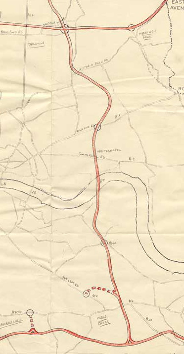
If it seems strange that one part of this otherwise brand-new ring road should use an existing road that was designed to help access a Victorian river tunnel and regenerate a deprived part of the city, which was built to a much lower standard with no expectation that any of it would be a motorway, then that's because it wasn't supposed to be this way. When the London County Council first started drafting a "motorway box" to surround central London in the early 1960s, they drew in entirely new North, West and South Cross Routes that became part of the GLC's Ringway 1 proposals, but they also drew in an East Cross Route on an entirely new line as well.
The original East Cross would have run further west, departing the North Cross Route at Dalston, then running south through Limehouse and Rotherhithe to meet the South Cross Route at New Cross. It would have been a brand new motorway on a new line, requiring a new tunnel under the Thames parallel to the one at Rotherhithe, and with this route on the map, Ringway 1 makes a lot more sense.
The exact process by which this motorway proposal dropped out of the programme is not clear, but it had been fully deleted by the time Ringway 1 was announced to the public in 1965. It's easy to imagine that, since the GLC were committed to building a new high-standard dual carriageway down the east side of London, which would connect to the North and South Cross Routes and would involve duplicating the Blackwall Tunnel, the construction of another motorway directly parallel to it would be hard to justify.
Instead, in 1966, engineers working on the Blackwall Tunnel Northern and Southern Approaches were asked to add hard shoulders to the existing design wherever there was space, and the sections that were of a sufficiently high standard were then designated a motorway.

So much for the brand new motorway, but there was also a third East Cross Route proposal. When Justice Layfield published his report, he recommended keeping Ringway 1, but with some modifications. His biggest criticism was that it ran much too far out from central London to serve as an inner ring road, especially in the south east. He proposed using only the northern half of the East Cross Route, building a motorway on a new line from Poplar, down through the Isle of Dogs to cross the river near Greenwich and meet the South Cross Route at St John's. By taking this route it formed a shortcut past the distant south-eastern corner of the box and would pass through the Docklands which were due for wholesale regeneration. It would also rescue picturesque Blackheath from the South Cross Route.
Unfortunately, this route never progressed further than a line on a map, though, as Layfield's report was published at a point where all the GLC's motorway proposals were effectively dead in the water anyway.
Loose ends
At the southern end of the road, the small junction south of Sun in the Sands was the site of the original terminus, where the motorway narrowed suddenly and dumped all its traffic on the built-up Rochester Way towards Eltham.
When the Ringway plans were dropped, the traffic situation in Eltham was so bad that the former A2(M) plan was resurrected and a short new section of East Cross Route was built to extend the road southwards to meet the new bypass. As a result, today the East Cross Route does reach Kidbrooke, but in place of the four-level interchange that was originally planned, it meets the Eltham Relief Road head-on and Kidbrooke Interchange is now a local junction. Even though the East Cross Route and the Eltham Relief Road are free-flowing expressways, the junction was built as a simple roundabout, and it is now a set of traffic signals.
The numbering for this road causes some confusion. When it was built, the whole road from Hackney Wick to Kidbrooke was classified A102 and A102(M). This seems a very unlikely number for a part of London's innermost motorway ring road, and it seems most likely that it was intended to be a temporary designation, but there is no evidence to suggest what its final number was supposed to be. Perhaps the whole circuit would have had one number. Today the section north of the tunnels is part of the A12, and south of Sun in the Sands is the A2.
Sources
- Bridges intended for railway goods yard; local sliproads meant to be temporary; tunnel to reduce impact on church: GLC/DG/PUB/01/379
- Planned layout at Kidbrooke; correlation between planned motorway and present A2: HLG_159/1257
- LCC plan for East Cross Route via Rotherhithe: MT 106/195
- Late addition of hard shoulders to Blackwall Tunnel approaches: UK Motorway Archive: A102(M) Blackwall Tunnel Southern Approach Road
Picture credits
- Route map contains OS data © Crown copyright and database rights (2017) used under the terms of the Open Government Licence.
- Partial diagram of Hackney Wick Interchange is from "North Cross Route: Engineering Report", Travers Morgan/GLC, August 1966.
- Plan of Kidbrooke Interchange extracted from the London Borough of Greenwich's evidence to the GLDP Inquiry, at HLG 159/1257.
- Plan of LCC proposal for the East Cross Route from MT 106/195.